Dr Leo Lymburner has published a new article in Hydrological Processes (https://onlinelibrary.wiley.com/doi/10.1002/hyp.15174) in which he uses adaptive shortwave infrared (SWIR) thresholding to map water inundation (i.e. flooding!) under wooded wetlands. This is a very exciting advance for understanding the extent of flood waters in Australia, especially as we have been experiencing more extreme wet weather in recent years.
The Lymburner et al (2024) conceptual model, shown in figure 1, explains how the magnitudes of the SWIR reflection, from Landsat and Sentinel data is exploited by this novel approach and linked to the presence of vegetation.

Figure 1. Conceptual model re: short-wave infrared wavelengths (SWIR) reflectance, open water, and tree canopies. Lymburner et al (2024).
Leo and his team tested the methodology across a range of sites in Eastern NSW with success, with assistance from local indigenous communities and the fleet of drones.
” Accuracy assessment based on independent drone imagery from a wide range of vegetated wetlands showed an absolute accuracy of 67%–70% and a fuzzy accuracy of 81%–83%. We found the method is conservative, and underestimates inundation (16%–18%) but very rarely misclassifies dry pixels as inundated (0.3%–0.6%). “ – Lymburner et al (2024)
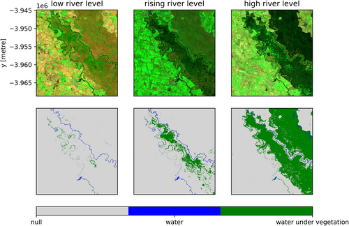
Their approach is visuslised in figure 2 and as you follow the rising of the river level, you can clearly see how thier method captures the ingress of water beneath the vegetation (as water levels increase).

Figure 2. Per time-slice short wave infrared mapping under vegetation (SWIM-UV) results for low-mid-high stage flows in the Gunbower, Perricoota and Koondrook forest. The top row shows the Landsat false colour image, and bottom row shows SWIM-UV extent. Lymburner et al (2024)
Studies like these improve the way use Earth Observation data to solve real world problems. How we undertsand the impacts of extreme events, in this case flooding, and its impact on our landscapes. This study is possible by a number of data sharing initiatives and the availablility of analysis ready data (ARD) and compute resources to conduct this kind of reseaerch, in the cloud, close to the very large ARD collections like Landsat and Sentinel (https://www.dea.ga.gov.au/).
Well done Leo and team! Great Work!
The full citation…
Seeing the floods through the trees: Using adaptive shortwave infrared thresholds to map inundation under wooded wetlands
Leo Lymburner, Catherine Ticehurst, Maria Fernanda Adame, Ashmita Sengupta, Emad Kavehei
First published: 02 June 2024
https://doi.org/10.1002/hyp.15174
