The NASA Surface Biology and Geology (SBG) mission and why Australia needs to support it  

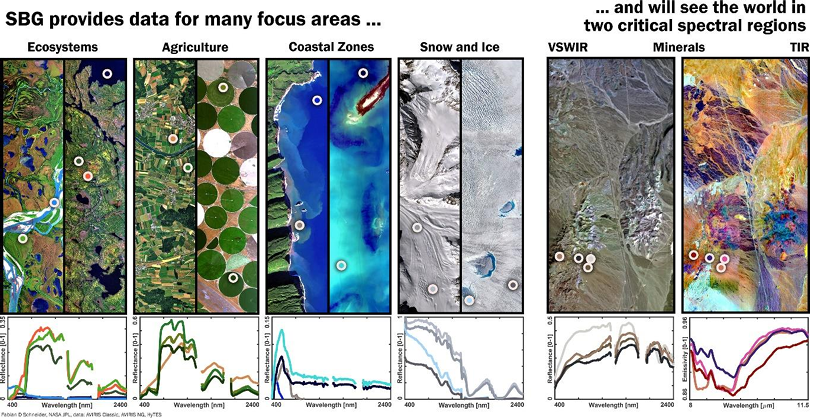
NASA is planning a hyperspectral space mission, Surface Biology and Geology (SBG) which is founded on findings of the National Academies of Sciences, Engineering and Medicine (NASEM) 2017 Decadal Survey titled Thriving on Our Changing Planet: A Decadal Strategy for Earth Observations from Space. http://sites.nationalacademies.org/DEPS/ESAS2017/index.htm

The decadal survey identified several ‘Very Important’ priorities, which stand to enhance the observational efficacy of Australian federal and state environmental agencies valuable ecological, hydrological and geological work. The most important priorities, and their relevance are highlighted below, and I have commented below each parallels with New South Wales Department of Climate Change,  Energy, the Environment and Water (DCCEEW) Biodiversity program and other Commonwealth initiatives:

Ecosystems

E1a: Quantify the distribution of the functional traits, functional types, and composition of vegetation and marine biomass, spatially and over time.

  • Plant traits are used to assess threatened species adaptive capacity.
  • Plant Community Types (PCT) are key to the NSW Biodiversity Offsets Scheme and represent ‘composition of vegetation’. Thus, function and composition are key defining elements of PCT’s.
  • Marine biomass, algae and cyanobacteria are ecological threats to our estuaries and waterways.

E1c: Quantify the physiological dynamics of terrestrial and aquatic primary producers.

  • The health of our rivers, their aquatic ecology, baseline monitoring  programs like UNE’s EcoHealth (https://ecohealth.une.edu.au) is an exemplar that focus on catchment scale assessment of aquatic ecosystems will be enhance by SBG’s data streams.
  • Australia’s own CSIRO AquaWatch Australia program will provide a ‘Weather service for water quality’ that further enhances this very important priority for our water ways.
  • International collaboration between Australia’s own HyVista Corporation (https://hyvista.com/ ) and the NASA AVIRIS team (https://aviris.jpl.nasa.gov/ ) on cal/val stands to further enhance high resolution hyperspectral (sub SBG pixel) data collection.

E2a: Quantify the fluxes of CO2 and CH4 globally at spatial scales of 100 to 500 km and monthly temporal resolution with uncertainty <25% between land ecosystems and atmosphere and between ocean ecosystems and atmosphere.

  • Ecosystem fluxes, over time, are key to understanding earths carbon and emissions cycles for reporting at all levels of Australian government.
  • Cal/Val for this on the ground is already provided (for decades) by the TERN OzFlux network across Australia (https://www.ozflux.org.au/)

Hydrology

H1c: Quantify rates of snow accumulation, snowmelt, ice melt, and sublimation from snow and ice worldwide at scales driven by topographic variability.

  • We often forget Australia gets snow in our Snowy Mountains and Tablelands, but as it is critical across the globe, it is here equally important to our ecosystems and hydrological climatology. SBG means more accurate snow information for Australia.

Solid Earth

S1a: Measure the pre-, syn-, and posteruption surface deformation and products of Earth’s entire active land volcano inventory at a time scale of days to weeks.

  • Locally in Australia we don’t have any active volcanoes, but we do regionally and these impact our climate.
  • What we do have is dust emissions that is relevant here, is dust emissions from our desserts and SBG will help us quantify these better.

What can you do ?

Seeing floods through the trees

Dr Leo Lymburner has published a new article in Hydrological Processes (https://onlinelibrary.wiley.com/doi/10.1002/hyp.15174) in which he uses adaptive shortwave infrared (SWIR) thresholding to map water inundation (i.e. flooding!) under wooded wetlands. This is a very exciting advance for understanding the extent of flood waters in Australia, especially as we have been experiencing more extreme wet weather in recent years.

The Lymburner et al (2024) conceptual model, shown in figure 1, explains how the magnitudes of the SWIR reflection, from Landsat and Sentinel data is exploited by this novel approach and linked to the presence of vegetation.

Figure 1. Conceptual model re: short-wave infrared wavelengths (SWIR) reflectance, open water, and tree canopies. Lymburner et al (2024).

Leo and his team tested the methodology across a range of sites in Eastern NSW with success, with assistance from local indigenous communities and the fleet of drones.

” Accuracy assessment based on independent drone imagery from a wide range of vegetated wetlands showed an absolute accuracy of 67%–70% and a fuzzy accuracy of 81%–83%. We found the method is conservative, and underestimates inundation (16%–18%) but very rarely misclassifies dry pixels as inundated (0.3%–0.6%). “ – Lymburner et al (2024)

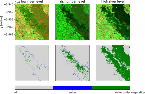
Their approach is visuslised in figure 2 and as you follow the rising of the river level, you can clearly see how thier method captures the ingress of water beneath the vegetation (as water levels increase).

Figure 2. Per time-slice short wave infrared mapping under vegetation (SWIM-UV) results for low-mid-high stage flows in the Gunbower, Perricoota and Koondrook forest. The top row shows the Landsat false colour image, and bottom row shows SWIM-UV extent. Lymburner et al (2024)

Studies like these improve the way use Earth Observation data to solve real world problems. How we undertsand the impacts of extreme events, in this case flooding, and its impact on our landscapes. This study is possible by a number of data sharing initiatives and the availablility of analysis ready data (ARD) and compute resources to conduct this kind of reseaerch, in the cloud, close to the very large ARD collections like Landsat and Sentinel (https://www.dea.ga.gov.au/).


Well done Leo and team! Great Work!

The full citation…

Seeing the floods through the trees: Using adaptive shortwave infrared thresholds to map inundation under wooded wetlands

Leo LymburnerCatherine TicehurstMaria Fernanda AdameAshmita SenguptaEmad Kavehei
First published: 02 June 2024
https://doi.org/10.1002/hyp.15174


OpenHSI ~ How it all began…

Firstly, if you don’t know what OpenHSI is, then I suggest you go and read it’s very excellent github site/pages: https://openhsi.github.io/


The ‘story’ is I was a chief investigator in the ARC Training Centre Cubesats, UAV’s and their applications, see: https://www.cuava.com.au/

I had a number of PhD students at the School of Physics at The University of Sydney at the time including Dr Yiwei Mao and Samuel Garske.

Professor Sergio Leon-Saval and Dr Chris Betters from SAIL were collaborating on hyperspectral imaging spectrometers, for cubesats.

Then COVID hit!

My students, collaborators and I were all stuck at home and we we got talking (on Zoom) about the work of Fred Signernes and his hyperspectral imager.

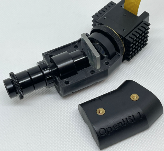
So we hatched a plan to iterate on Fred’s design, and Sergio and Chris got on the case and produced a design,… we all tinkered away on our parts (especially Chris and Yiwei) from home (often on the kitchen table) and then when COVID broke, we had a hyperspectral imager, OpenHSI 1, as pictured above (note: the SAIL logo is on the side not in view!).

Yiwei and Sam got to work applying it, testing it and developing software and anxcillaries for it, and published their work !… and OpenHSI was born.

Dr Yiwei Mao has so far published a number of papers on OpenHSI as part of his (now passed!) PhD Thesis:


https://doi.org/10.3390/rs14092244
OpenHSI: A Complete Open-Source Hyperspectral Imaging Solution for Everyone
by Yiwei Mao, Christopher H. Betters, Bradley Evans, Christopher P. Artlett, Sergio G. Leon-Saval, Samuel Garske, Iver H. Cairns, Terry Cocks, Robert Winter, Timothy Dell

https://doi.org/10.1016/j.solener.2023.111821
High resolution imaging spectroscopy of the sky
by Yiwei Mao, Chris H. Lee, Charles M. Bachmann, Bradley J. Evans, Iver H. Cairns


https://doi.org/10.3390/s23208622

A Customisable Data Acquisition System for Open-Source Hyperspectral Imaging
by Yiwei Mao, Christopher H. Betters, Samuel Garske, Jeremy Randle, K. C. Wong, Iver H. Cairns, Bradley J. Evans